
Local Election Results

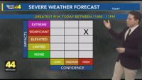
Today we have another threat for severe weather. Today's threat is looking more likely and more hazardous than yesterday's threat. All the ing…


Evansville, IN
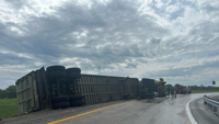


Drivers should use caution in the area until the scene is clear.

With the threat of severe weather in the area Wednesday, several locations will be opening their doors to offer shelter from the storms.

Local schools will be letting out early Wednesday due to the threat of severe weather in the area.


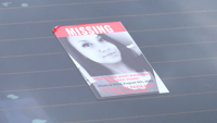
Evansville Police have confirmed new details on the investigation into missing woman Andi Wagner.


Kentucky State Police say a former Owensboro Police officer was indicted Tuesday after a recent 2023 investigation.


While unconfirmed by law enforcement, family and friends believe two search warrants served in Oakland City on Tuesday could be in connection …